Research Overview
Water Conservation to Reduce Wet Weather Pollution Discharges to New York City’s Waterways:Pilot Study in the Gowanus Canal, Brooklyn, NY
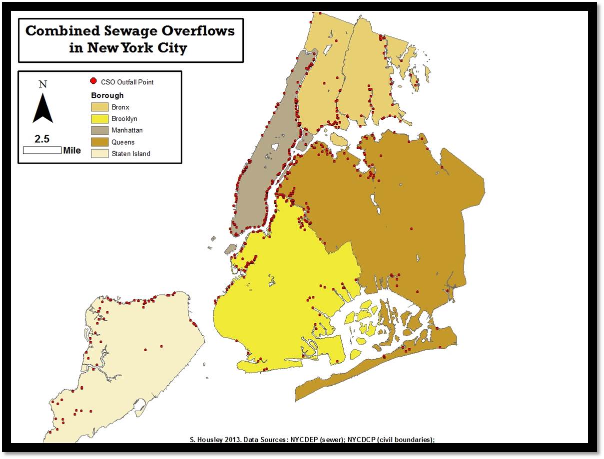
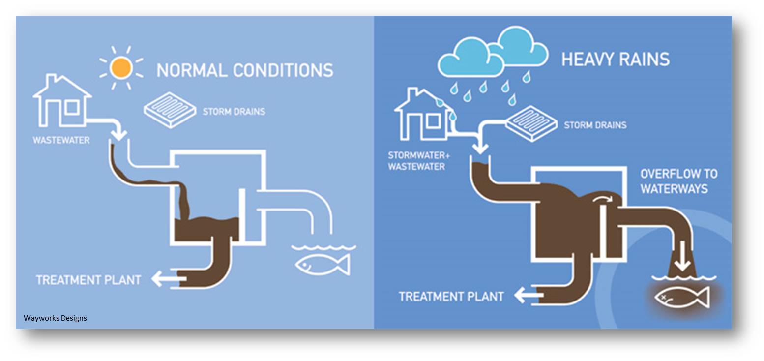 New York City is subject to Combined Sewage Overflows (CSOs) when its combined sewage/stormwater system is overwhelmed, which often occurs during rain events. As displayed in the map below, there are hundreds of CSOs discharging untreated sewage and stormwater to the waters of NYC. These discharges are associated with a wide array of pollutants including human pathogens, heavy metals, and excess nutrients.
Stormwater is typically managed using what are termed “best management practices” (BMP’s). The purpose of these controls is to capture wet weather pollution at its source, rather than allowing it to discharge into traditional storm-sewer/ CSO systems. The term BMP commonly refers to structural mechanisms such as bio-retention, wet/dry detention ponds, and other engineered controls; but also includes non-structural components such as policy changes and educational programs.
New York City is currently under a consent order to do something about the CSO issue. Several efforts are underway including the city-wide Sustainable Stormwater Plan and the Green Infrastrcture Plan. These strategies focus on reducing the stormwater portion of the combined flow in order to reduce stress on the system and lower pollutant loads. For my dissertation project, I chose to focus on a community-based BMP that would target the sewage portion of the combined flow.
The goal of this project is to assess the potential of promoting residential water conservation during storm events as a community-based, non-structural BMP

Most of the water used in NYC (aprox .77%) is for residential purposes. Therefore, much of the raw sewage released during CSOs must also be from residential sources, making it a good target for this BMP. A household could participate by reducing the amount of water they use for flushing toilets, washing dishes, taking showers, etc. during storm events; thereby reducing the stress on the CSO system during the time of highest demand.
Pilot Study: Gowanus Canal Sewershed
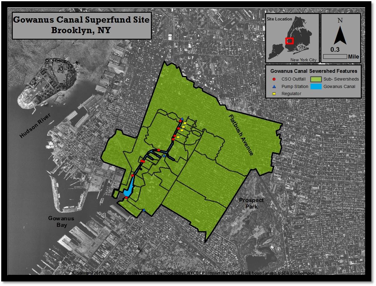
This study utilizes the Gowanus Canal, a 1.5 mile-long waterbody in Brooklyn, NY as a case study to examine water conservation during storm events as a way to reduce wet weather pollution loads in urban areas with combined sewer systems. The Gowanus Canal was designated as a Superfund site as of April 2010. Though the Superfund designation refers specifically to historical pollution associated mainly with the sediments of the Canal, combined sewer overflow (CSO) discharge from 10 outfalls represents an additional threat to the waterbody that must be managed.
Modeling for this project was carried out using PCSWMM stormwater modeling utility. Preliminary results indicate that water conservation could reduce wet weather flow volume at the outflow by up to 15%. Modeled pollutant load reductions were larger- ranging from 10-35% for TSS and Fecal Coliform, to 5-20% for heavy metals. These reduction values are comparable to small or medium scale green infrastructure BMPs, and would come at considerably less cost. However, community buy-in would be required.
A quantitative community survey was distributed in order to determine the community’s interest in participation. Citizens were asked about their willingness to reduce their water use during rain events overall, for specific water uses, and for specific periods of time. They were also asked questions about their level of concern about CSO pollution.

Preliminary results indicate that, on average, community members are concerned about pollution from CSO’s and would be willing to reduce their water use during rain events in order to lower the amount of sewage reaching the Gowanus Canal.
Future Work
Additional modeling will be carried out in order to determine the expected annual impact that the water conservation BMP could have on the Gowanus Canal. The model will be validated using flow-meter data from the NYCDEP, and Area-Weighted Landuse/Pollutant data from the USEPA and NYCDCP. Results from the community survey will be incorporated into model simulations to produce the most realistic indications of potential impacts.


1 Comment
September 3rd, 2013 at 3:50 pm
[…] Research Overview […]
Leave a Reply