October 10th, 2013
Research Update
Here is a video update about my research, including some preliminary survey results.
Thanks to the New York New Jersey Harbor Estuary Program for filming the presentations at their Citizen Science Workshop.
Here is a video update about my research, including some preliminary survey results.
Thanks to the New York New Jersey Harbor Estuary Program for filming the presentations at their Citizen Science Workshop.
When I was a freshman in college, I took an oceanography course. Being a nerd, I still remember one of the questions on our final exam:
“You MUST go swimming in New York City. Explain where you would choose to swim and why you would choose that particular location. Back up your explanation with examples from the course.”
At the time I wrote that answer, I never even dreamed that I’d be living in NYC one day. After living here for just over 3 years- I must admit- I’ve never gone swimming here-and I’m not sure that I ever would!
New York City has over 200 miles of shore- front public space and they are working to make it safer for recreation (in compliance with the Clean Water Act). There are several spots approved for fishing and boating, but if I had to go swimming today, I think I’d stick to a pool.
I had to laugh when I saw this article over the summer with the tag line: “Where can I swim in NYC, and is it going to kill me”? They offer some pretty sound advice (Dr. Duedall would be proud!). So, what do you think? Would you ever swim in NYC?…and please explain your answers!
Citizen science, sometimes called crowd-sourced science, is when researchers engage with the local community, or even the global community to help gather data and solve problems. Scientific American has a page dedicated to the phenomena, and there seems to be no limit to what citizen scientists can do. Projects range from the search for life on other planets, to the mapping of roadkill here on Earth.
Many communities (example, example, example) are utilizing citizen scientists to help mark storm drains and collect useful qualitative data about the condition of the drains. Other communities lean on the help of citizen scientists to help monitor local water quality (example, example, example).
The information collected by citizen scientists can be used in a variety of ways. One group in Pennsylvania is using their data to help build maps detailing how water quality changes during wet and dry conditions, which they will then use to improve their local stormwater models. The Charles River Watershed Association even created a App to help students and watershed volunteers quickly upload all of the great data they are collecting.
Citizen Scientists are doing a lot here in NYC, too. So much so that the NY-NJ Harbor Estuary Program is hosting a Citizen Science Water Quality Monitoring workshop later this month (Sept. 18th, to be exact). The workshop will cover the basics of the combined sewage/stormwater system we have here in NYC, how we can track water quality, and how we can work together to improve it. I am excited to be speaking about my dissertation project during one of the morning sessions.
If you’re interested in learning more or getting involved, it would be great to see you there!
I have been noticing a lot of talk lately about the proposed keystone pipeline and all the jobs it would or would not have created. Then I stumbled across this interesting article from Daily Progress about how tighter environmental regulations are creating a “boon” for the stormwater industry (there is a connection here, I promise) . The article is specifically talking about new developments, but it got me thinking about how our Country’s stormwater system is really a pipeline system….and how it really needs some work!
Let’s consider all the regions currently relying on combined stormwater and sewage systems:
According to the USPEA, there are roughly 40 million people, residing in 772 communities that are regularly exposed to the public health threats associated with combined sewage overflows. According to Rose, et al, 2011 ” if climate variability increases, current and future deficiencies in areas such as watershed protection, infrastructure, and storm drainage systems will probably increase the risk of contamination events”. Let’s all agree that this is not good.
Seperate stormwater pipelines! Miles and miles of them. How many “person years” of work would be created if we got to work separating these systems? (No, really- is there an economist out there who can figure this out?).
Of course I know this is not a magical solution– separate stormwater systems are not without their problems, and all of this costs money, an estimated 50.6 Billion dollars over the next 20 years to be exact. However, for perspective- when economists utilize the “social cost of carbon” estimates , it’s expected that the Keystone pipeline will generate 72.3 Billion dollars in costs.
I’m far (far!) from being an economist, but I think this is interesting. Everyone wants jobs, and if we must have pipeline related jobs- which ones would really be better for our Country?
It was announced earlier this Summer that the Gowanus Sponge Park, designed by the Gowanus Canal Conservancy and dlandstudio, is going to happen! Construction should start next year and be completed in 2015.
From what I can tell, “Sponge Park” is the way that creative people say “constructed wetland and bio-filtration system”. The word “sponge” refers to the wetland plant’s ability to absorb and/or trap pollutants, something we left-brained types call “phytoremediation“. The park will be planted with species specially chosen to absorb pollutants in the canal, specifically heavy metals (like lead and mercury) and Polychlorinated biphenols (PCBs) which are known to be a big problem in the canal.
While I was working in Florida, I monitored a project called Chain of Lakes, that is pretty similar to the Sponge Park, so I am excited to see how this system works. Here is a rendering of what the sponge park will look like when it is finished (from NYdailyNews):
When we are talking about phytoremediation, plants can be classified as (1) non-accumulators who do not take up many pollutants at all; (2) accumulators who take up some pollutants; or (3) hyper-accumulators who can take up 100x to 1000x more pollutants than non-accumulators and still remain healthy plants. It is these hyper-accumulators that are typically used for relatively low cost, aesthetically pleasing remediation projects like the sponge park.
Plants have many tricks up their sleeves (branches?) to remove pollution. This Review from the International Journal of Chemical Engineering has a great breakdown:
For these last two, where pollutants are detained in the root system, there are more remediation processes at work. Some plants can release special enzymes from their roots that aid in further breaking down pollutants. For example, certain enzymes are known to act as catalysts that speed up the microbial dechlorination of PCBs. This image from VanAiken and Gieger, 2010 shows a possible pathway:
Phytoremediation is what we call an in-situ or “on site” process. This is cool because in addition to filtering pollutants before they reach the canal, the plants themselves will hold a record of the types and amounts of pollutants that are entering the canal.
According to this diagram from the report on the park, stormwater will be diverted from the combined storm/sewer system and redirected to flow through the park before eventually being released into the canal. Studying what is trapped by the plants in the park could help us learn more about the sources of stormwater pollutants in the Gowanus sewershed.
The sponge park definitely has more style than any stormwater project I’ve seen before (this is Brooklyn, after all). So, while it’s doing it’s job filtering pollution, the park will double as some much needed waterfront access for the region, and hopefully raise awareness of the unique environmental issues the canal faces. Who knows, maybe someday the water will even sparkle like it does in this conceptual drawing (from dlandstudio).
My husband is an avid surfer- as are many of the friends I collected while living in Florida for 10 years. Yet somehow even living on a barrier island and working for a stormwater utility– I did not think much about the connections between stormwater and surfing. It was not until a trip to Mexico where I saw raw sewage draining into the water my [now] husband was surfing that I really thought about it- and of course, took pictures:
Cooper did not get sick or anything- but it turns out a lot of surfers do. According to a recent article in the New York Times, surfers in Los Angeles often complain of pink eye, fevers, and diarrhea when surfing after a rain storm. There is published research to back this up. A paper in Marine Pollution Bulletin found that due to high bacteria levels, the risk of gastro-intestinal illness to be elevated when surfing after a rain storm as compared to a non-rainy day. They also found that the risk of surfing was greater than the risk of swimming due to the higher likelihood of ingesting the polluted water. Another paper published in the Journal of Geophysical Research notes that the fecal bacteria released from storm outfalls tends to hug the shoreline and travel parallel to the shore for a long time before becoming “diluted” into the ocean (which, as we all know, is the solution to pollution).
Many coastal communities provide educational materials to their residents to inform them about the role they play in stormwater pollution (like this brochure from Honolulu, HI). Money collected from local stormwater utility fees can be used to install engineering controls that filter or hold the contaminated stormwater before it reaches the beaches (like these systems installed in Myrtle Beach, SC). A lot of effort is also put into making better warning signs (like these from New Hampshire) and keeping people from getting in the water in contaminated areas.
A study from the University of Southern California models a way to distribute beach amenities (parking, bathrooms, etc.) in a way to encourage beach goers to spend time at safer beaches, as opposed to those close to stormwater pipes. The article does not talk to much abut surfers specifically, which I find interesting- because, in my opinion, they are subset of beach goers who probably are not going to be detoured by a lack of any amenities- and might actually prefer it that way. Along these lines, the community at Surfers Point in Santa Barbara, California is participating in an “organized retreat” from the shoreline in order to combat stormwater pollution and erosion. This method combines conservation efforts with engineering controls such as permeable pavement and bioretention systems; it isn’t something that would work everywhere but it it one of the best approaches I’ve seen.
Do you surf even after it rains? Have you ever gotten sick? What are some of the special concerns of surfers vs. other beach goers that planners need to keep in mind?
And- while we’re at it, someone should start an American chapter of Surfers Against Sewage– an awesome UK-based organization- check out their short video at drift surfing, and a great paper co-written with Surfrider.
As my friends who’ve recently made the mistake of asking me how my day is going already know- I am currently compiling data from a community survey that I’m distributing as part of my dissertation research. A few weeks ago, I sent the survey out to selected households in the geographic area that contributes to the combined sewage overflows in the Gowanus Canal. Judging from the results I have thus far, it seems that many people were really surprised to hear that they lived in this area (and that their sewage was going into the canal!). More than one person wrote me a personal note with their returned survey to tell me that there was “no way” this was true. This surprised me at first, but the more I thought about it- the more it made sense.
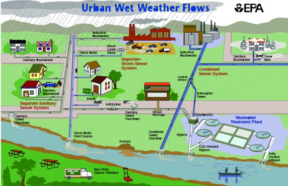
We never really see water flow in the city except for rain running down the street and into a drain- not exactly natural. Like it or not, we live in a totally engineered world here in NYC. That being so, the concept of “watershed“ we learned in high school doesn’t necessarily apply to the way water flows here. This is why I think the term “sewershed” is more appropriate for urban areas, especially those with combined storm and sewer systems like we have here in NYC. The concept is similar to that of a watershed, but reflects that instead of flowing naturally, rain water flows into pipes where it mixes with sewage and is diverted to wherever engineers and city planners have decided it should go (which may or may not be where it would have naturally wound up). This image from the USPEA is a good example of a how an urban sewershed works:

Diagram of how urban sewersheds function with separate (left) and combined (right) stormwater/sewage systems.
When the local water treatment plants are overwhelmed during rain events, stormwater and raw sewage from the region in the map below are discharged into the Gowanus Canal via 10 outfall pipes (red dots on the map). The boarders are a bit jagged in spots, but I labeled the streets as well as I could so you should be able to get a general sense of the region.
Do you live in this zone? I used to live over in the Prospect Heights area and was really surprised to learn that region drained to the Gowanus Canal.
Do you live in another part of the City and would like to know your sewershed?
This should not be a surprise to you if you’ve been keeping up with the local headlines, or perhaps the HBO series Bored to Death– which dedicated an entire episode to this pressing local issue.
Every time the City’s combined sewage and stormwater system gets overwhelmed- raw sewage is released into the waters of NYC, so it makes sense that the occasional nasty bacteria or virus makes its way into the Canal. However, I have yet to see any published data which refers specifically to STDs. Bonus points to anyone who can find this data from a credible source!
The canal is far from safe, and is most definitely teeming with bacteria- not to mention the 100’s of historical pollutants that helped earn the Canal its Superfund status. Here is what I was able to find in regards to bacteria levels:
As this last point implies, the scary bacteria issue is not limited to the Gowanus. Harmful bacteria and other pollutants from combined sewage overflows are a problem for all of NYC’s waterbodies. As I was walking home today through Brooklyn Bridge Park (one of the City’s finer parks, might I add) I passed an obvious combined sewage overflow site. The scene got me thinking that perhaps the Gowanus is not the only NYC waterbody with potential STDs lurking amongst the flotsam.
How many condoms can you spot in this sewage overflow?
(I stopped counting at 10)
As a Maryland native and a stormwater professional- it’s hard to believe I’ve held off on this one for so long, but after seeing headlines like this, and this, and this– I decided it was time to do some research.
In the past month, it was announced that Maryland will begin to phase in a stormwater utility fee, beginning with its 10 largest jurisdictions. The reaction has been pretty intense- and the misleading nickname of the new fee as a “rain tax” has not helped. Personally, Given the state of the Chesapeake Bay, I was shocked (shocked, I tell you!) that this action was not taken sooner.

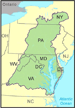
The Chesapeake Bay Watershed: Almost every single drop of rain that falls in Maryland will eventually make its way into the Chesapeake Bay (Map: epa.gov)
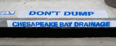
Unlike the unfortunate nickname suggests, these fees will not be levied to any greater extent when it rains a lot (nor to a lesser extent during a drought). They will be a steady fee each month. Stormwater utilities are already pretty common in other areas of the Country, and average below $5 per month. The fee amount is determined by the size of your property and the amount of impermeable area it contains. Impermeable areas are those where rainwater cannot sink in ( like roofs and parking lots). Rain that falls over these areas will runoff into local waterbodies- which- for almost the entire state of Maryland- means the Chesapeake Bay. When rain water runs off your property it is not clean anymore- it sweeps up any oils, greases, metals, pesticides, and other pollutants that it comes in contact with and carries them along into the nearest body of water, which eventually makes it’s way to the Bay. No matter where you live in Maryland, you’ve probably seen warning labels on the storm drains alerting you to this fact:

Storm Drains in Maryland lead to the Chesapeake Bay- or smaller bodies of water that eventually empty into the Bay (image: usda.gov)
The money from the fees will be used to build and maintain projects to help clean the pollution that is already in the Bay, and to prevent future stormwater pollution from reaching the Bay. These projects include retention ponds, bio-swales, and rain gardens to hold and filter runoff water until in can soak into the ground. More information of the types of projects being considered can be found here.
The fees may also be used to support outreach and education efforts to deliver industry specific information on avoiding stormwater pollution to businesses, workshops for homeowners, and educational programs for school students.

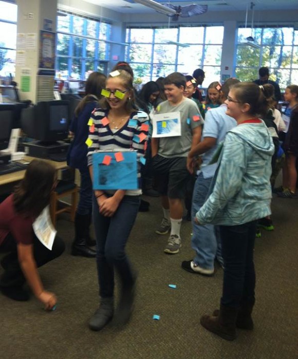
Future Good Citizens: Students in Maryland simulate a rain storm to learn how rain water gets polluted, and how they can prevent it from happening in the future
In my opinion, this new stormwater utility is a good thing. The funds generated will aid in restoring our Country’s largest watershed, and should create jobs in the process. So please, don’t call it a “rain tax”- instead of getting “information” from misleading headlines- get the news straight from the horse’s mouth (that’s how that saying goes, right?) Here is what the State of Maryland has to say on the issue.
~Suzie
The record setting rainfall we’ve had over the past few days has caused yet another round of combined sewage overflows (CSOs) into the Gowanus Canal. While out for a walk today, I took these shots of the sewage floating along. Images like this make it really hard for me to imagine why the City is fighting the EPA’s “request” that they engineer a solution as part of the Superfund clean-up.
If your’re concerned- The next general community advisory group meeting will be on May 28th!