Wednesday, June 26th, 2013...6:03 pm
Know your Sewershed!
As my friends who’ve recently made the mistake of asking me how my day is going already know- I am currently compiling data from a community survey that I’m distributing as part of my dissertation research. A few weeks ago, I sent the survey out to selected households in the geographic area that contributes to the combined sewage overflows in the Gowanus Canal. Judging from the results I have thus far, it seems that many people were really surprised to hear that they lived in this area (and that their sewage was going into the canal!). More than one person wrote me a personal note with their returned survey to tell me that there was “no way” this was true. This surprised me at first, but the more I thought about it- the more it made sense.
Watershed VS. Sewershed
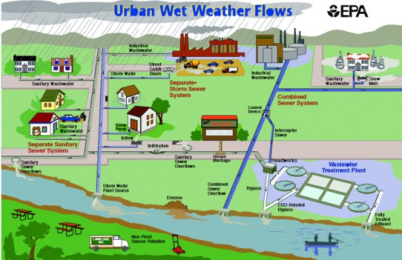
We never really see water flow in the city except for rain running down the street and into a drain- not exactly natural. Like it or not, we live in a totally engineered world here in NYC. That being so, the concept of “watershed“ we learned in high school doesn’t necessarily apply to the way water flows here. This is why I think the term “sewershed” is more appropriate for urban areas, especially those with combined storm and sewer systems like we have here in NYC. The concept is similar to that of a watershed, but reflects that instead of flowing naturally, rain water flows into pipes where it mixes with sewage and is diverted to wherever engineers and city planners have decided it should go (which may or may not be where it would have naturally wound up). This image from the USPEA is a good example of a how an urban sewershed works:

Diagram of how urban sewersheds function with separate (left) and combined (right) stormwater/sewage systems.
So where is the Gowanus Canal Sewershed?
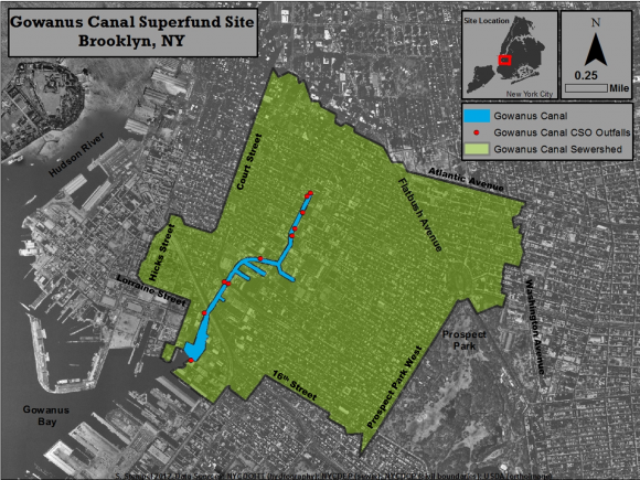
When the local water treatment plants are overwhelmed during rain events, stormwater and raw sewage from the region in the map below are discharged into the Gowanus Canal via 10 outfall pipes (red dots on the map). The boarders are a bit jagged in spots, but I labeled the streets as well as I could so you should be able to get a general sense of the region.
Do you live in this zone? I used to live over in the Prospect Heights area and was really surprised to learn that region drained to the Gowanus Canal.
Do you live in another part of the City and would like to know your sewershed?
- Check out the Citizens Guide to the Sewershed from the LES Ecology Center . This document focuses mainly on Newtown Creek, but has great information for the rest of the City too.
- The City Parks Dept. has made some cool maps of the sewersheds draining to the Bronx River.
- More maps and water quality data are available through PlaNYC‘s Sustainable Stormwater Plan.


1 Comment
August 15th, 2013 at 4:41 pm
[…] According to this diagram from the report on the park, stormwater will be diverted from the combined storm/sewer system and redirected to flow through the park before eventually being released into the canal. Studying what is trapped by the plants in the park could help us learn more about the sources of stormwater pollutants in the Gowanus sewershed. […]
Leave a Reply